


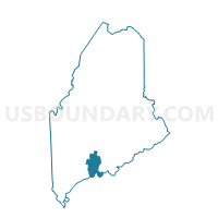
Voting District 200513, Lincoln County, Maine
About
Outline

Summary
| Unique Area Identifier | 591589 |
| Name | Voting District 200513 |
| County | Lincoln County |
| State | Maine |
| Area (square miles) | 47.28 |
| Land Area (square miles) | 41.47 |
| Water Area (square miles) | 5.81 |
| % of Land Area | 87.71 |
| % of Water Area | 12.29 |
| Latitude of the Internal Point | 44.04842780 |
| Longtitude of the Internal Point | -69.54492270 |
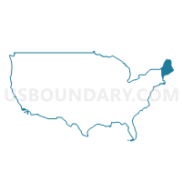
Maps

Graphs
Select a template below for downloading or customizing gragh for Voting District 200513, Lincoln County, Maine


Neighbors
Neighoring Voting District (by Name) Neighboring Voting District on the Map
- Voting District 200502, Lincoln County, ME
- Voting District 200511, Lincoln County, ME
- Voting District 200512, Lincoln County, ME
- Voting District 200523, Lincoln County, ME
- Voting District 200531, Lincoln County, ME
- Voting District 200533, Lincoln County, ME
Top 10 Neighboring County Subdivision (by Population) Neighboring County Subdivision on the Map
- Waldoboro town, Lincoln County, ME (5,075)
- Wiscasset town, Lincoln County, ME (3,732)
- Bristol town, Lincoln County, ME (2,755)
- Jefferson town, Lincoln County, ME (2,427)
- Damariscotta town, Lincoln County, ME (2,218)
- Newcastle town, Lincoln County, ME (1,752)
- Nobleboro town, Lincoln County, ME (1,643)
- Edgecomb town, Lincoln County, ME (1,249)
- South Bristol town, Lincoln County, ME (892)
- Bremen town, Lincoln County, ME (806)
Top 10 Neighboring Place (by Population) Neighboring Place on the Map
Top 10 Neighboring Elementary School District (by Population) Neighboring Elementary School District on the Map
Top 10 Neighboring Secondary School District (by Population) Neighboring Secondary School District on the Map
Top 10 Neighboring Unified School District (by Population) Neighboring Unified School District on the Map
- Regional School Unit 12, ME (14,838)
- School Administrative District 40, ME (14,764)
- Bristol, ME (2,755)
- Jefferson, ME (2,427)
- Nobleboro, ME (1,643)
- Edgecomb, ME (1,249)
- South Bristol, ME (892)
Top 10 Neighboring State Legislative District Lower Chamber (by Population) Neighboring State Legislative District Lower Chamber on the Map
- State House District 51, ME (8,935)
- State House District 53, ME (8,779)
- State House District 52, ME (8,660)
- State House District 50, ME (8,388)
- State House Districts not defined, ME (0)
Top 10 Neighboring State Legislative District Upper Chamber (by Population) Neighboring State Legislative District Upper Chamber on the Map
Top 10 Neighboring 111th Congressional District (by Population) Neighboring 111th Congressional District on the Map
Top 10 Neighboring Census Tract (by Population) Neighboring Census Tract on the Map
- Census Tract 9755, Lincoln County, ME (6,122)
- Census Tract 9751, Lincoln County, ME (5,276)
- Census Tract 9752, Lincoln County, ME (5,075)
- Census Tract 9753, Lincoln County, ME (3,861)
- Census Tract 9754, Lincoln County, ME (3,710)
- Census Tract 9756, Lincoln County, ME (3,630)
- Census Tract 9757, Lincoln County, ME (892)
Top 10 Neighboring 5-Digit ZIP Code Tabulation Area (by Population) Neighboring 5-Digit ZIP Code Tabulation Area on the Map
- 04572, ME (5,075)
- 04578, ME (4,450)
- 04348, ME (2,976)
- 04543, ME (2,218)
- 04553, ME (1,752)
- 04555, ME (1,643)
- 04556, ME (1,249)
- 04539, ME (1,168)
- 04551, ME (806)
- 04535, ME (709)